Click on the image for a larger version.
Back to map |
Image
details:
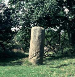
This milestone stands in its original position, immediately east
of Vindolanda on the Stanegate. This is the medieval name for the
Roman road built by Agricola and his successors, linking frontier
towns and forts from Corbridge to Carlisle. In some places modern
minor roads still run along its line, elsewhere as at Vindolanda
the road runs only as a farm track or path. This milestone was not
inscribed but would perhaps have borne a painted inscription, indicating
the distance from Corbridge , like other milestones along the Stanegate,
and the name of the reigning emperor. They helped travellers en
route, but also served as a reminder of imperial power on the fringes
of empire.
Image ownership:
© Vindolanda Trust
|