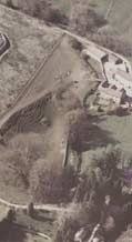
The visible remains of the site at
Vindolanda mostly date to the later phases of its existence. In
the centre the playing-card shape walls outline the second stone
fort at Vindolanda, constructed in the early third century. In the
middle of the fort the remains of the commander's residence, the
praetorium, and the headquarters building, the principia,
have been excavated and displayed. To the left lie the remains of
the vicus, the civilian settlement beyond the walls of the fort,
including shops and houses. The tower and fortifications below the
vicus (on the left-hand side of the picture) are a reconstruction
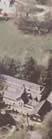
of a section of Hadrian's Wall. To the right, part of the museum
is visible and above it a farmhouse and buildings. Above the site
runs a track which still follows the route of the Roman road linking
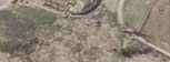
Corbridge and Carlisle, the Stanegate. The tablets were found among
the remains of the earliest timber forts on the site. Of these almost
no traces are visible on the surface, but they extended across the
whole of the site, beneath both the stone fort and vicus.
Running the mouse over the aerial photograph below will highlight
areas where a close-up image and further information are available
on the visible archaeological remains, almost all of late Roman
date, at Vindolanda.
Alternatively, there is also a text
description of the photographs.
|