Click on the image for a larger version.
|
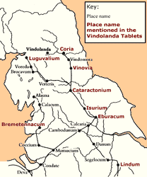
Image
details:
The Roman road network and settlements in
northern Britain.
Image ownership:
Alan Bowman |
The earliest phases at Vindolanda, from which the tablets derive,
belong to this poorly understood period between the withdrawal from
Scotland and the building of Hadrian's Wall. The tablets themselves
make little specific reference to political or military events.
There is however a tantalising fragmentary reference to the conduct
of a census (304). A census was required
to turn a conquered area into a normal part of a province, assessing
its people for tax and possibly recruitment into the Roman army.
It would not be surprising to find a census conducted in northern
Britain at this time, several decades after the first arrival of
the army. A note on the fighting capacities of the Britons (164)
perhaps indicates an assessment of their suitability as recruits.
Following the retreat from Scotland, Vindolanda sat on the outer
rim of a network of auxiliary garrisons that extended across the
whole of northern England, with the legions stationed to the rear
at York and Chester. The roads built to support the military advance
through northern Britain were also critical to communication between
garrisons and the control of conquered territory, as well as being
a reminder in the landscape of Roman domination.
The three most important routes were the two north-south routes
into Scotland, and the east-west route linking Corbridge (Coria)
and Carlisle (Luguvalium). Of the two main routes into Scotland,
the eastern ran through Corbridge, the western through Carlisle.
Both routes were fed by Dere Street, running east of the Pennines
and dividing at Scotch Corner, just north of Catterick
(Cataractonium). Dere Street continued to Corbridge via a series
of garrisons that included Binchester
(Vinovia). The road to Carlisle branched northwestward,
crossing the Pennines over Stainmore between Bowes and Brough, and
headed north-west to Carlisle and beyond. Alternatively one could
travel north along the western side of the Pennines from Chester,
via Ribchester (Bremetennacum),
to Carlisle. One of the tablets seems to record expenses incurred
on a journey north along Dere Street, stopping at Aldborough (Isurium),
Catterick and Binchester (185).
Modern trunk routes in northern England and southern Scotland, the
A1, A68 and A66 still follow the lines of these Roman roads in many
places.
Vindolanda itself lies on the 'Stanegate', built by Agricola or
his successors, connecting Corbridge to Carlisle through the gap
in the Pennine hills cut by the rivers Tyne and Irthing. The name
of the road is medieval but the route is Roman. The Stanegate perhaps
marked the limit of Roman control but may have been a patrolled
road rather than a formal frontier line, allowing the movements
of the Britons to be monitored. The milestones set up along the
Stanegate and other roads by third and fourth century emperors,
presumably to record repairs, show the continuing importance to
the army of these strategic routes. In some places modern roads
still follow the Stanegate, but much of its course is remembered
only in farm tracks, as at Vindolanda, or in field boundaries.
|